
- This event has passed.
Open to Public – Oct 25, 2019 – Castle Hot Springs – Walker’s Gulch Ride (Lake Pleasant area)

Oct 25, 2019 – Castle Hot Springs – Walker’s Gulch Ride (Lake Pleasant area)
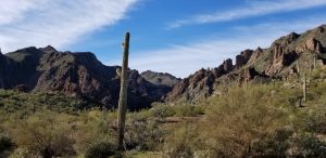
This is a last minute spur of the moment ride. On Friday Oct 25th, at 9:00 AM, Bill Poppo and I will lead a few Phoenix ATV/UTV Club members on a ride north of Lake Pleasant up to Castle Hot Springs down through Castle Creek through Walker’s Gulch and return via Cow Creek Road. This is a 40-50 mile clockwise loop desert hills ride that takes 5 hours (with scenic stops & lunch) through some varied and beautiful desert / mountain scenery. Bring a camera for those Kodak moments.
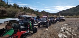
ALL MEMBERS, GUESTS, VISITORS, AND POTENTIAL NEW MEMBERS ARE WELCOMED ON THIS RIDE. IF YOU HAVE AN EXTRA SEAT IN YOUR SXS OR UTV FOR THE RIDE, CALL OR EMAIL ME TO LET ME KNOW. I have a few friends that would like to go on this ride.
This is one of my FOUR POINTS OF THE COMPASS rides that gives members, visitors, and potential new members a chance to explore new areas that they might not normally ride. This is also one of those fun rides where you want to bring the wife, family, or that friend that you been wanting to convince about getting into ATV riding to come along. Hopefully, the weather will cooperate for this Saturday.
DIRECTIONS TO STAGING AREA AND START TIME
The general riding area is north of Lake Pleasant. Assuming an approach from I-17, take Carefree Highway (AZ-74) west 11.4 miles to Castle Hot Springs Road which is on the west side of Lake Pleasant. Turn north on Castle Hot Springs Road and go north 5.5 miles. There are two parking lot staging areas on both sides of the road about 2 city blocks before the road curves and ends at a T-intersection and stop sign by the north park entrance to the Castle Creek boat launch and campground. Google Maps has the approximate GPS coordinates at N33° 54.247′ W112° 19.558′ or by copying the following map coordinates [33.904117, -112.325967] into Google Maps Satellite view. The ride will stage at the roadside parking lot and depart at 9:00AM after the 8:45AM safety meeting. Get there early to unload and meet-and-greet other riders.
RIDE DESCRIPTION
Set OHV odometer to zero (0) at the roadside staging area. Turn north on Castle Hot Springs Road and go north 0.3 miles until it curves and ends at a T-intersection and stop sign by the north park entrance to the Castle Creek boat launch and campground. Turn left (north) at the stop sign onto Castle Hot Springs Road where it becomes a dirt road. There is a lot of oncoming traffic through the area so be careful. At 2.5 miles, you will cross the land bridge over a portion of Lake Pleasant. At 3.1 miles, you will hit the intersection of Cow Creek Road and Castle Hot Springs Road. Stay heading straight (north) on Castle Hot Springs Road. Watch for wild burros through this next area. There are two distinct family herds (one grey and one black) along the Castle Hot Springs Road river bottom. Proceed through river bottom mining community and canyons for 4.6 miles to the Castle Hot Springs Resort at the base of Governor’s Peak Mtn [7.7 – first stop to stretch legs and take pictures]. We will continue around the resort and down the road through a scenic desert / mountain area (lots of Kodak moments so don’t be afraid to stop). The Hell’s Canyon Wilderness Area will be on the northside of the road in the distance. Watch for cows on all the roads. Proceed for 1.9 miles to Champie Road intersection [9.6 – second quick stop to make sure everyone turns left]. Another 1.0 mile and we hit the Buckhorn Road intersection [10.6- third quick stop to collect everyone). Proceed right and down into Castle Creek river bottom. This is a soft and sandy area due to the winter rains washing a lot of sand into the creek bed. Depending on the recent rain in the northern watershed, Castle Creek may have some shallow water in it. There is a 1.5-mile sandy stretch that usually has a meandering creek 6” to 12” deep flowing back-and-forth. A lot of times it is bone dry during the year. Look for shallow crossings and watch your trail buddy. We will stop at the Walker’s Gulch intersection [13.4 – water bottle break]. From there, head east through a fence gate and continue in Castle Creek 5 miles to see the HooDoo rock formations and “Charles Schulz Pictograph”. We would return on the same side route back to the Walker’s Gulch entrance. Proceed into Walker’s Gulch. We’ll have a lunch break at the Lookout Viewpoint [26.8]. Turn right (south) at the Walker’s Gulch Rd intersection with Cow Creek Road [28.6 – quick stop to collect everyone]. There is a gate at 32.0. The tail gunner should close and lock the gate. We pass the CK Road (back road to Crown King) at 34.5. We pass through the mining community of Columbia at 36.4 and pass the east end intersection of Champie Road at 38.5. There are numerous Kodak moments approaching what I call “Half Dome” at 39.3. We continue south on Cow Creek Road to the Castle Hot Springs intersection and turn left (south) [46.1 – quick stop to collect everyone]. Stay on Castle Hot Springs heading south to the roadside staging area [49.6]. Hang around for a few moments to say Goodbye to your fellow riders and to make sure everyone made it back.
WALKER‘S GULCH LOOP RIDE
Miles Odometer
0.0 0.0 Roadside staging area
3.1 3.1 Head north at Castle Hot Springs Road & Cow Creek Road intersection
4.6 7.7 Castle Hot Springs Resort (first stop)
1.9 9.6 Champie Road intersection (west end) – quick stop to collect riders. Turn left
1.0 10.6 Buckhorn Road (quick stop to collect riders. Turn right and down into Castle Creek)
2.8 13.4 Walker’s Gulch intersection (water bottle break – proceed west towards Copperopolis)
5.0 18.4 Charles Schultz Pictograph & HooDoo Rock Formations
5.0 23.4 Walker’s Gulch intersection (water bottle break – proceed into Walker’s Gulch)
1.1 24.5 Huge water hole on northside of trail – watch for cows in road.
2.4 26.9 Lookout Point (stop for lunch & snacks)
2.3 28.2 Mineshaft next to Road
0.4 28.6 Cow Creek Road intersection with Walker’s Gulch Road (turn right onto Cow Creek Rd)
3.4 32.0 Gate (tail gunner closes the gate)
2.5 34.5 Back road to Crown King Road intersection
1.9 36.4 Mining community of Columbia
2.1 38.5 Champie Road intersection (east end) – continue south on Cow Creek Rd
0.7 39.3 Kodak moment – “Half Dome”
5.1 44.4 Cow Creek Air Strip OHV staging area
1.7 46.1 Turn left (south) at Castle Hot Springs Road & Cow Creek Road intersection
3.1 49.2 Roadside staging area
TRAIL RATING
I have not been on the Walker’s Gulch trail since January so I don’t know the current trail conditions due to recent rains. It is usually rated an overall Easy-to-Moderate Ride [Level 1-2, Green-Blue] but could occasionally have some difficult sections resulting from a recent washout. Definition: May have some spots that are off-camber; some hilly/rocky spots or few steep slopes; recommended for riders with more than 12 months of riding experience). UTVs / SxSs / ROVs okay on this trail. 2WD vehicles s/b okay. Low range gear recommended for a very few rocky areas. Two-Up ATVs okay for passengers.
TAIL GUNNER NEEDED
I need a tail gunner for the ride if any member wants to volunteer. Otherwise, a responsible rider will be appointed at the staging area.
COMMUNICATION
Leader, mid-pack wingmen, and tailgunner will be on GMRS/FRS Channel 5 (sub-channel 0) in case you want to bring your walkie-talkies or CB / HAM radios. I think the UHF channel frequency is 462.6625 MHz depending on your radio. I highly recommend bringing a walkie-talkie to listen to approaching traffic and trail conditions.
VEHICLE & EQUIPMENT REQUIREMENTS
All ATVs, UTVs, & SxSs should be street-legal and have the Arizona Off Highway Vehicle Decal sticker. Dress appropriately and keep hydrated. Bring a lunch, snacks, and beverages. Bring a camera for those Kodak moments. Depending on the size of the group, the ride will be about 40 miles in 5 hours including the meal & scenic meet-and-greet stops. Extra fuel is usually not required but each driver should know their vehicle’s gas consumption and plan accordingly.
Helmet that is properly fitted, fastened, and has a USDOT safety rating for those 18 years of age and younger who ride on an OHV. Riders in an OHV such as a ROV / UTV / SxS or similar vehicle, while recommended for safety, do not require a helmet unless a rider is under 18 years of age. The Phoenix ATV/UTV Club promotes the use of helmets on all its rides. Eye protection is required for operators of vehicles not equipped with a windshield. You should use common sense for eye protection, bandanas, scarves, and dust masks for large group riding due to the dust conditions anyway.
SAFE, ETHICAL and RESPONSIBLE OPERATION OF YOUR VEHICLE
All Phoenix ATV/UTV Club members, visitors, and guests are expected to have appropriate vehicle registration, license, and personal insurance and to operate their vehicles in a responsible manner. The Phoenix ATV/UTV Club is a responsible member of the OHV riding community. As such the Club promotes safe and responsible operation of OHVs during club rides. Arizona Revised Statute 28-1381 prohibits the operation of motorized vehicles, including OHVs, while under the influence of any substance that may impair the operator’s judgment or ability. Therefore, the Club prohibits the consumption or use of any substance during a club ride that has the potential to impair the operator’s judgment or ability.
Live to Ride… Ride to Live! Happy Trails…
Bob Maitzen
President, Phoenix ATV/UTV Club
(480) 363-7723
Bob.Maitzen@gmail.com