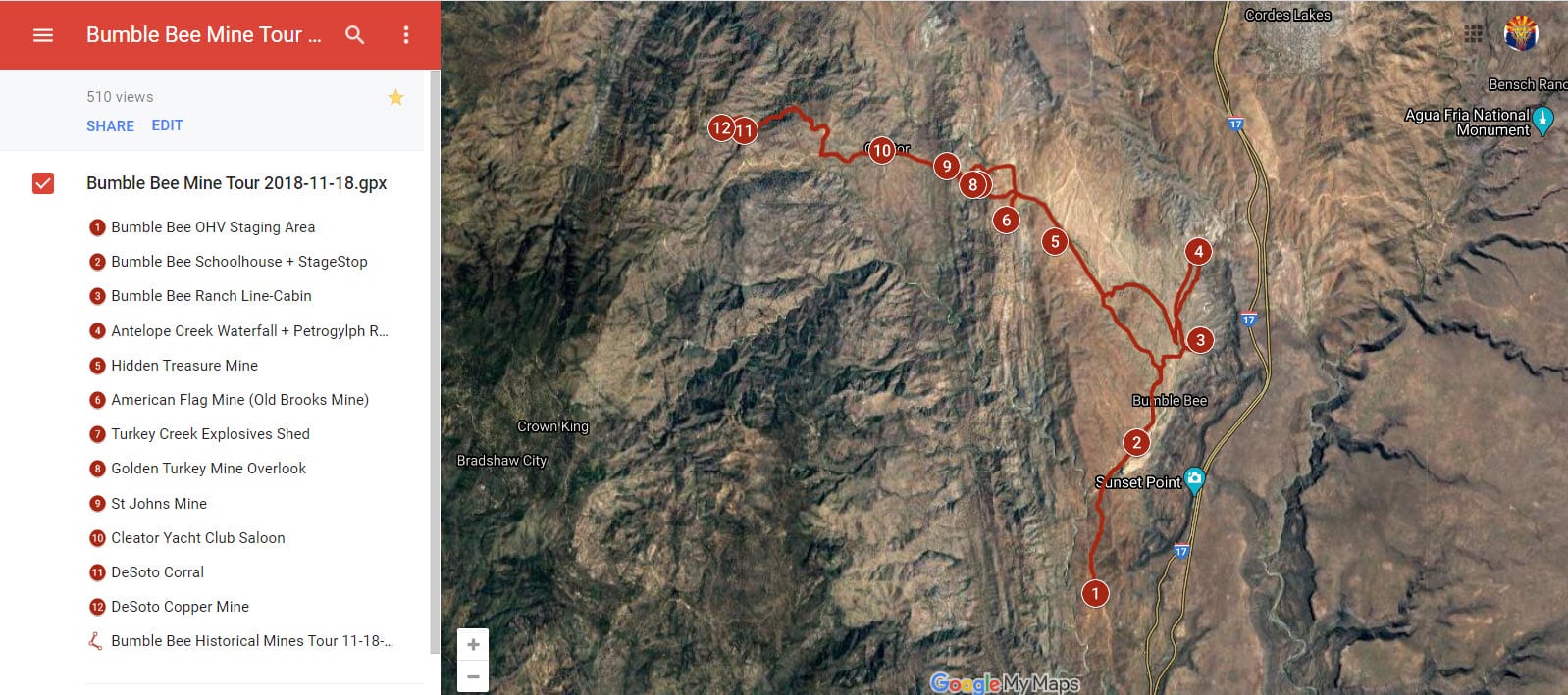
GPS Track + Map
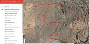
Bumble Bee OHV Area
Trail Rating: Easy-Moderate
(Level 1-2; Green-Blue)
41.5 miles (2419'-4818')
Bumble Bee OHV Area
Bumble Bee Ranch Line Cabin - Antelope Creek Waterfall - Government Springs Wash - Hidden Treasure Mine - American Flag Mine - Golden Turkey Mine -
Cleator Yacht Club Saloon - Desoto Mine -St Johns Mine
GPS Track + Map
Bumble Bee OHV Area
Historical Mines Tour
© Phoenix ATV/UTV Club
Trail Rating: Easy-Moderate
(Level 1-2; Green-Blue)
41.5 miles (2419'-4818')
Bumble Bee OHV Area
Bumble Bee Line Cabin - Antelope Creek Waterfall - Government Springs Wash - Hidden Treasure Mine - American Flag Mine - Golden Turkey Mine - Cleator Yacht Club Saloon - Desoto Mine -
St Johns Mine
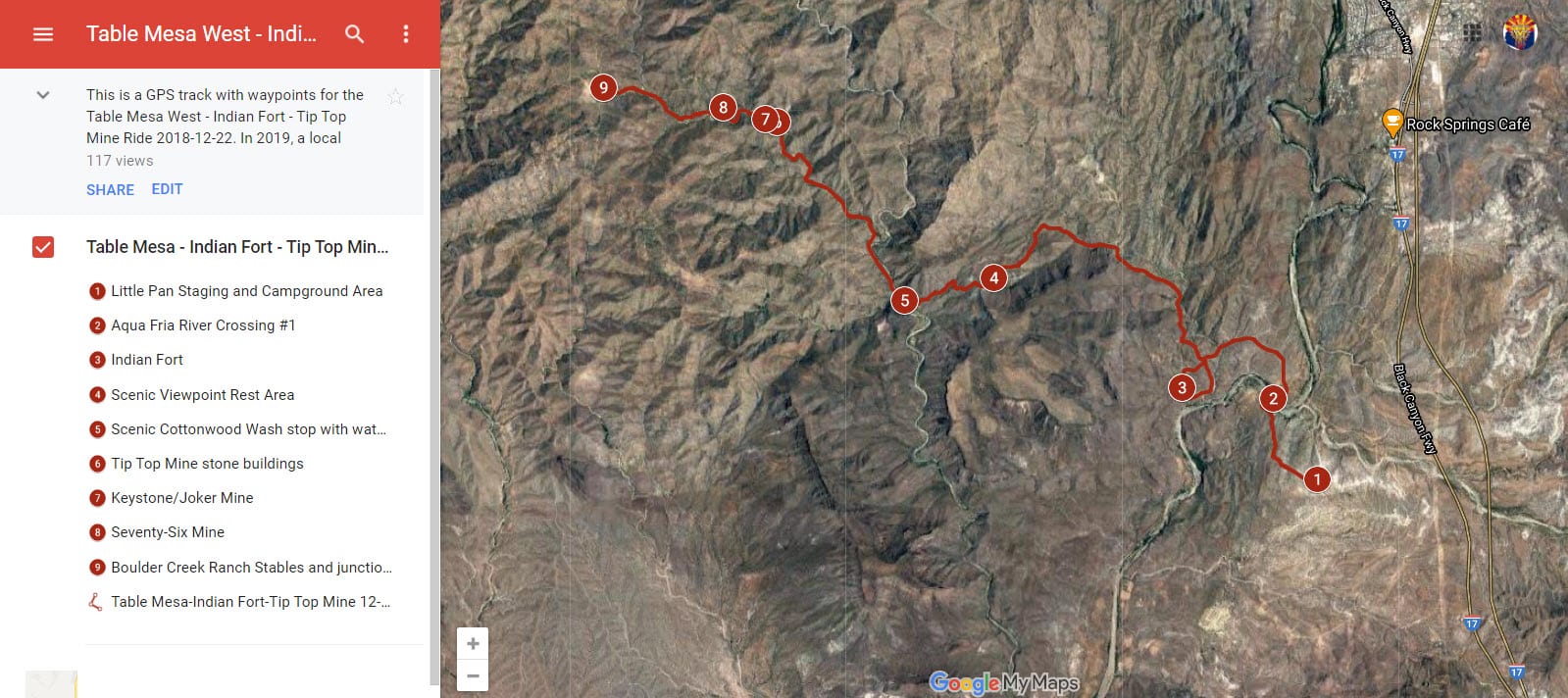
GPS Track + Map
Table Mesa OHV Area West - Indian Fort - Tip Top Mine
© Phoenix ATV/UTV Club
Trail Rating: Easy-Moderate
(Level 1-2; Green-Blue)
23.4 miles (1800'-2882')
Table Mesa West OHV Area
- Little Pan Staging Area & Campground Area
- Indian Fort
- Cottonwood Creek Viewpoint
- Tip Top Mine stone cabin ruins
- Keystone/Joker Mine
- SeventySix Mine
- Boulder Creek Stables
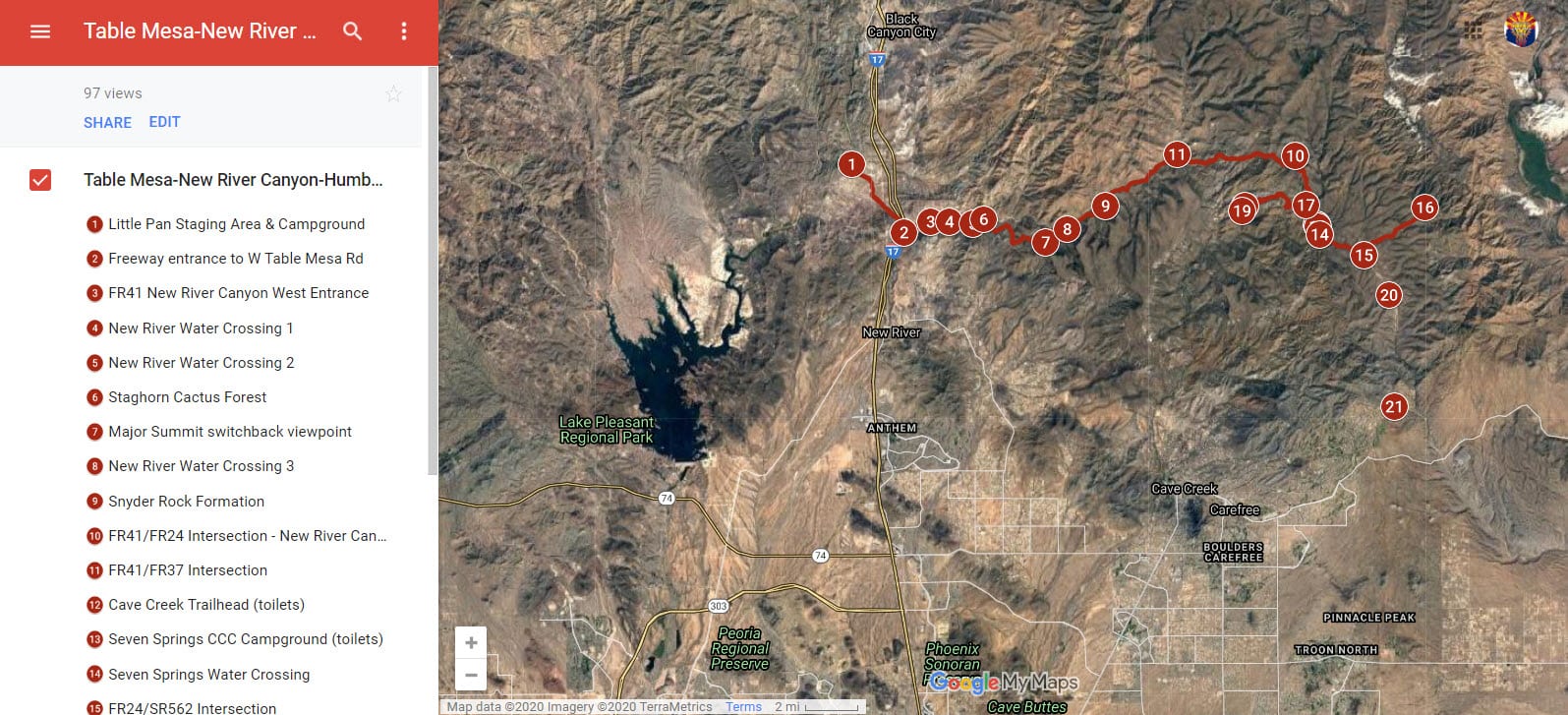
GPS Track + Map
Table Mesa East
- New River Canyon Trail
- Humboldt Mtn Radar Installation
- Big Maggie May Trail
© Phoenix ATV/UTV Club
Trail Rating: Moderate-Difficult
(Level 2-3; Blue-Red)
74.1 miles (1923'-5178')
Table Mesa East through New River Canyon Trail - Staghorn Cactus Forest campground - FR41 Vista Viewpoint - Snyder Rock Formation - Seven Springs CCC Campground - Humboldt Mtn FAA Radar Installation + Big Maggie May Trail + cabin ruins
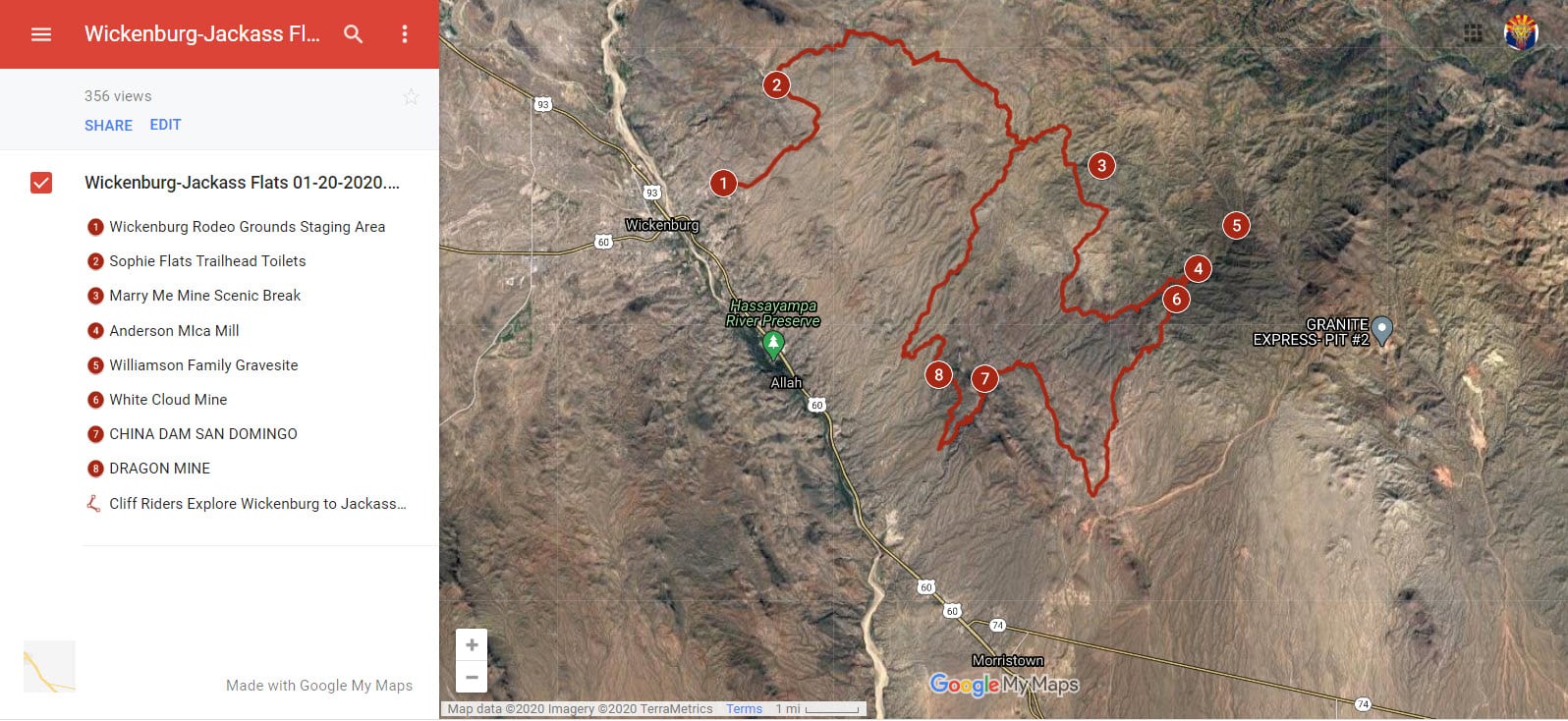
GPS Track + Map
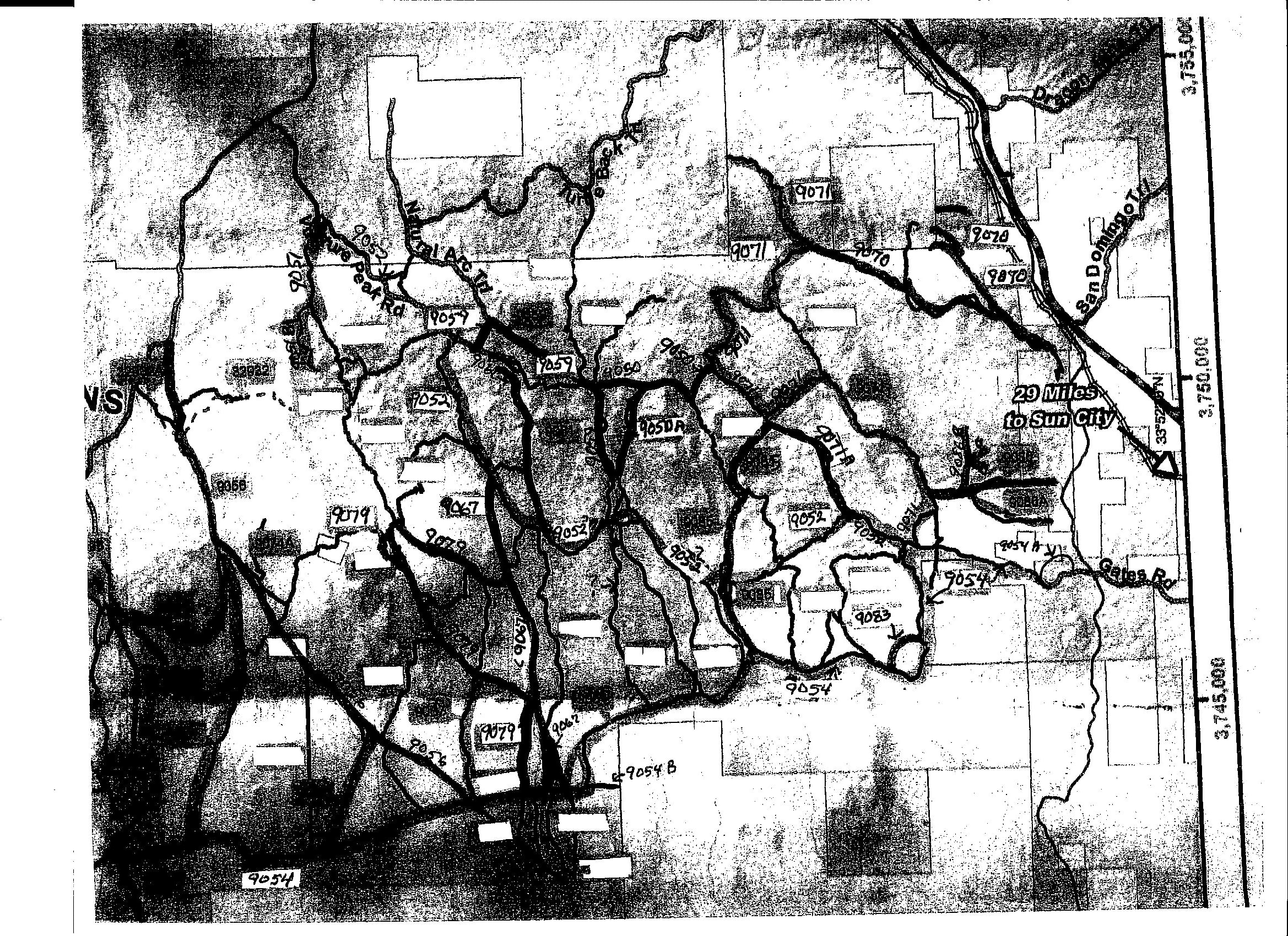
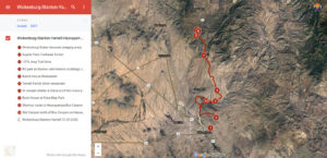
Wickenburg - Jackass Flats OHV Area
© Phoenix ATV/UTV Club
Trail Rating: Moderate-Difficult (Level 2-3; Blue-Red)
52.0 miles (2203'-2883')
Wickenburg Rodeo Grounds
- Sophies Flat Trailhead
- Blue Tank Wash
- Jackass Flats OHV Area
- Anderson Mica Mill
- Underwood Family Gravesite
- Tin Shed Cabin
- China Dam
- Dragon Mine
Trail Map
Vulture Mtn OHV Area
Photocopy PDF file
of Vulture Mtn OHV Area
near Morristown / Wickenburg with hundreds of miles of interlocking trails
- Courtesy of Mike Hann who laid out the trail marker system
GPS Track + Map
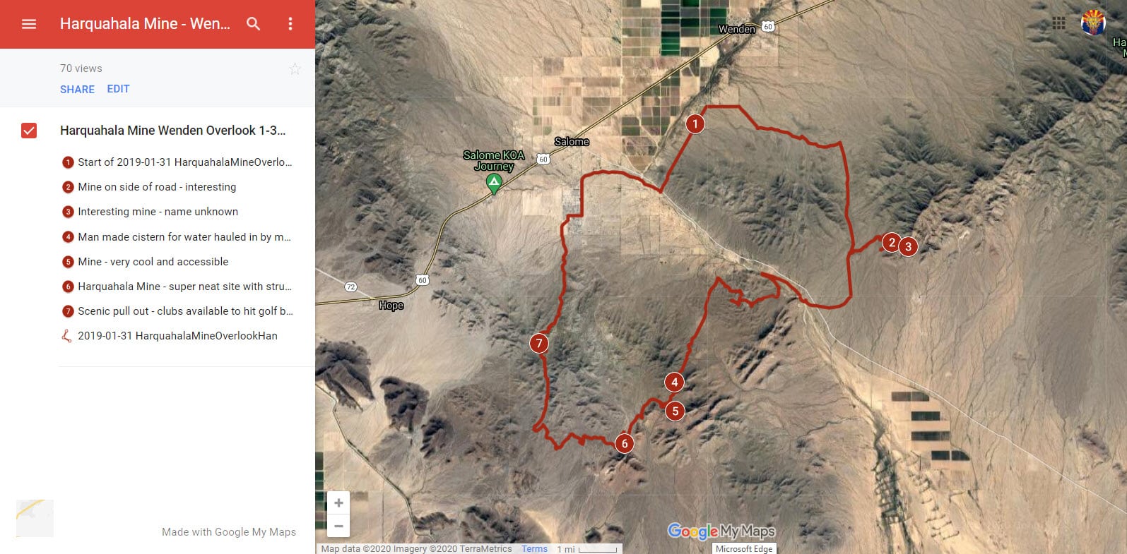
Harquahala Mine - Wenden Overlook
© Phoenix ATV/UTV Club
Trail Rating: Moderate
(Level 2; Blue)
43.9 miles (1604'-2311')
Haraquahala Mine Route - numerous mines - Wenden Overlook Viewpoint
GPS Track + Map
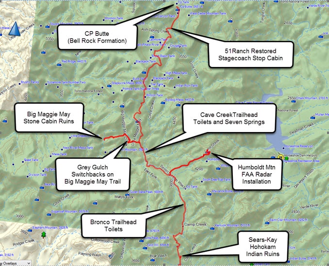
Cave Creek - Humboldt Mtn - Big Maggie May Trail - CP Butte
© Phoenix ATV/UTV Club
Trail Rating: Easy
(Level 1; Green)
38.0 mile (3207'5139')
N Scottsdale/Carefree AZ
Cave Creek Mining District riding area
-Cave Creek to Humboldt Mtn FAA Radar Installation
- Seven Springs CCC Campground
- Big Maggie May Trail
- 51Ranch Restored Stagecoach Stop Cabin
- CP Butte rock formation
GPS Track + Map
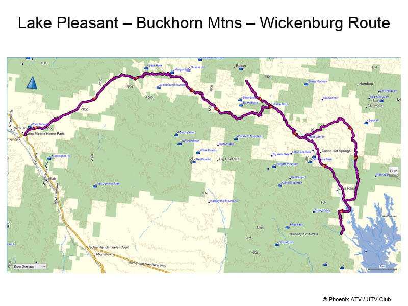
Lake Pleasant - Castle Hot Springs - Hoodoo Rock Formations - Buckhorn Mtns - Wickenburg
© Phoenix ATV/UTV Club
Trail Rating: Easy
(Level 1; Green)
83.8 miles (1730-4199')
Lake Pleasant OHV Area
- Castle Hot Springs
- Snoopy Mural
- Hoodoo Rock Formations
- Buckhorn Mtns
- Wickenburg (lunch stop)
GPS Track + Map
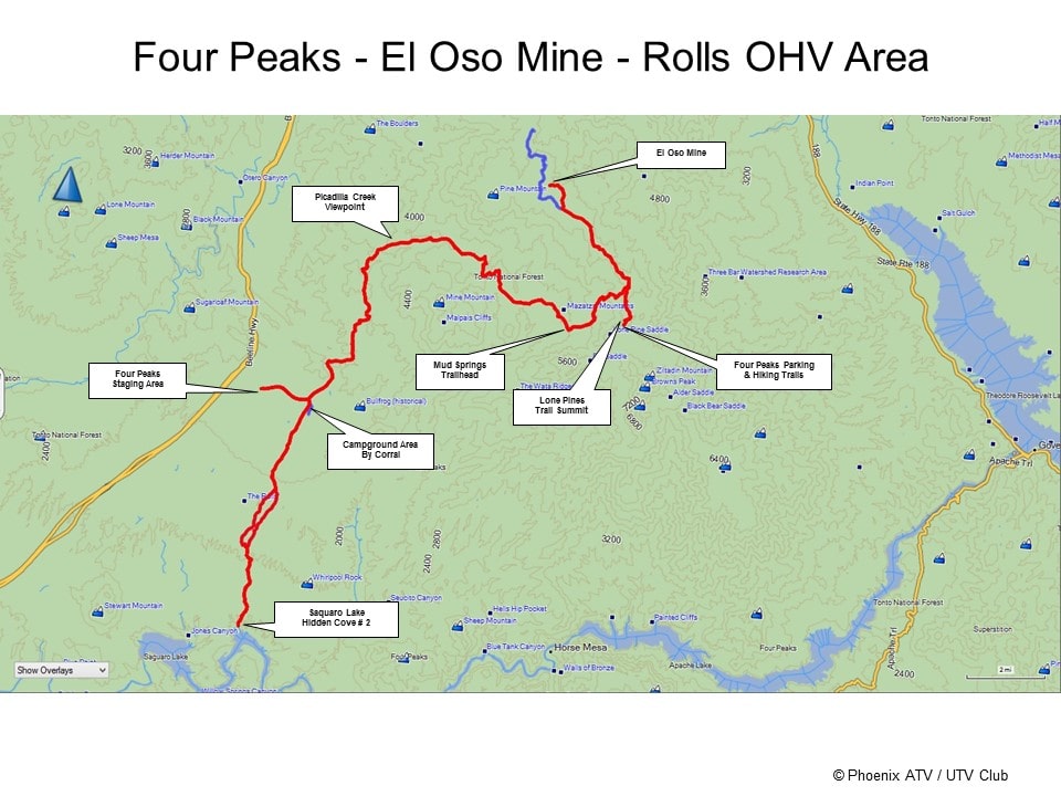
Four Peaks - EL Oso Mine - Rolls OHV Area - Saquaro Lake Hidden Cove #2
© Phoenix ATV/UTV Club
Trail Rating: Easy-Moderate
(Level 1-2; Green-Blue)
58.6 miles (1525'-5877')
Four Peaks/Rolls OHV Area
- Four Peaks Lone Pines Summit
- EL Oso Mine
- Mud Springs Trailhead
- Picadilla Creek Viewpoint
- Rolls OHV Area
- Saquaro Lake Hidden Cove #2
GPS Track + Map
Bumble Bee - Crown King - Horsethief Basin Recreation Area
© Phoenix ATV/UTV Club
Trail Rating: Easy-Moderate
(Level 1-2; Green-Blue)
77.6 miles (2559'-6863')
Bumble Bee OHV Area & Bradshaw Mtns
- Bumble Bee Line Cabin
- Hidden Treasure Mine
- Golden Turkey Mine
- Cleator AZ
- Poland Vista Viewpoint
- Crown King AZ
- Hazlett Hallow CCC Campground
- Horsethief Basin Mtn Lake
- Lookout Tower
GPS Track + Map
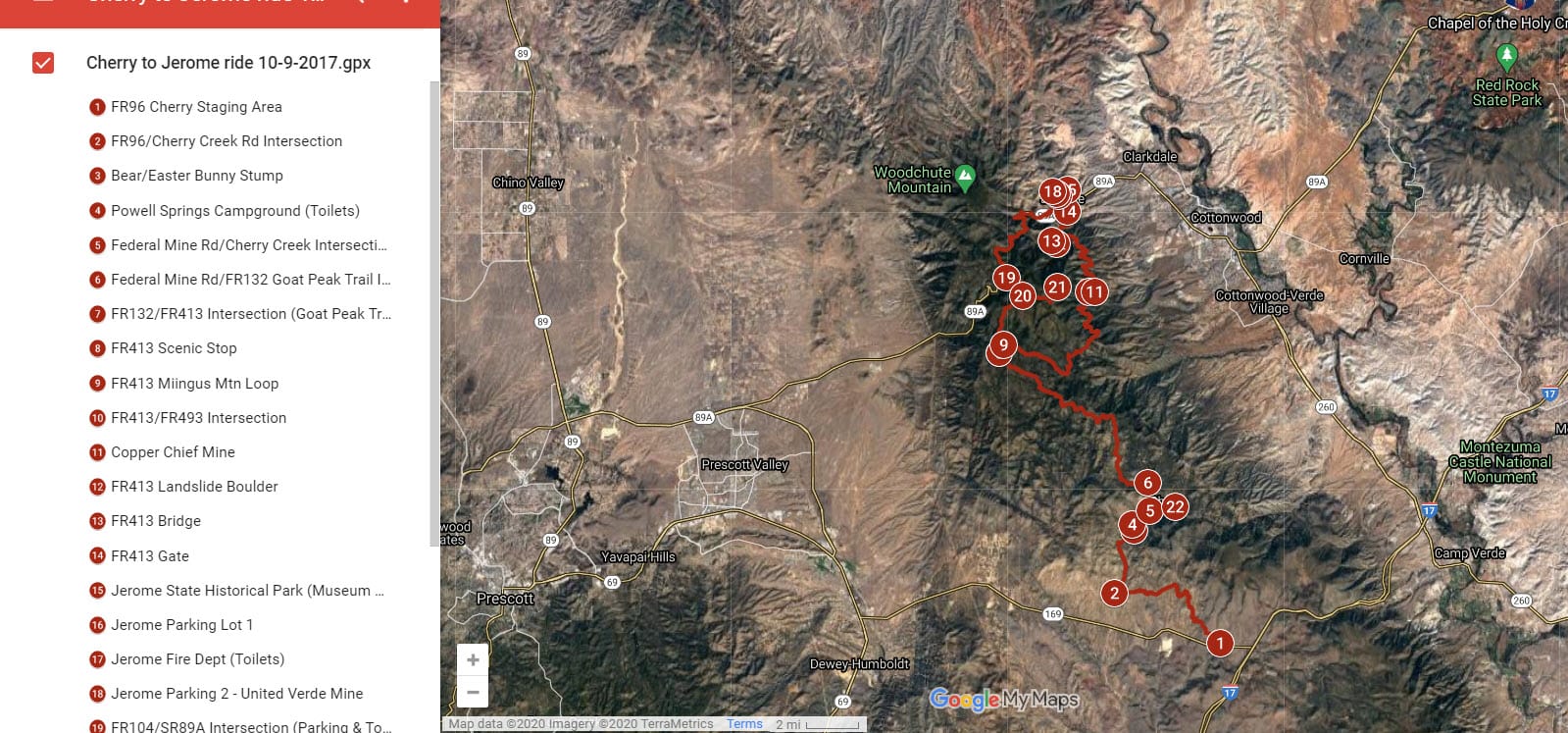
Cherry - Mingus Mtn - Jerome
© Phoenix ATV/UTV Club
Trail Rating: Moderate-Difficult (Level 2-3; Blue-Red)
86.0 miles (4552'-7769')
Mingus Mtn/Jerome Area
- Cherry - Goat Peak Trail
- FR413 Mingus Mtn Loop
- Jerome AZ
- Jerome State Historical Park (Museum Mansion)
- Mingus Mtn Hang Gliding Platform Viewpoint
GPS Track + Map
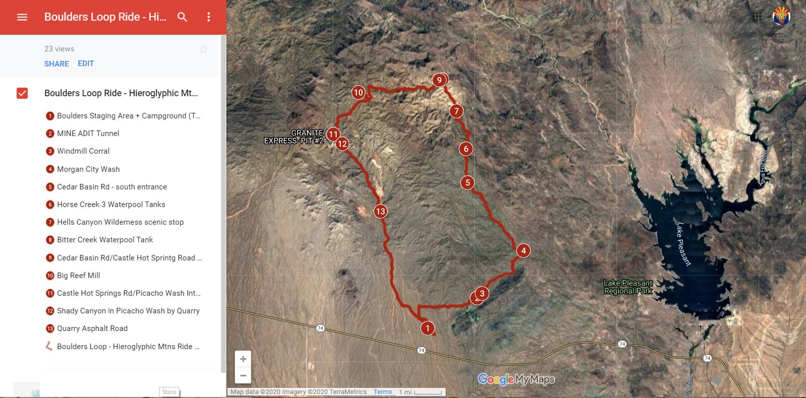
Boulders OHV Area Loop - Hieroglyphic Mtns
© Phoenix ATV/UTV Club
Trail Rating: Easy-Moderate (Level 1-2; Green-Blue)
31.4 miles (1972'-3372')
Boulders OHV Area + Campground
- Scenic loop ride to Morgan Wash + Cedar Basin Road along edge of Hells Canyon Wilderness area + Big Reef Mill + Picacho Wash
GPS Track + Map
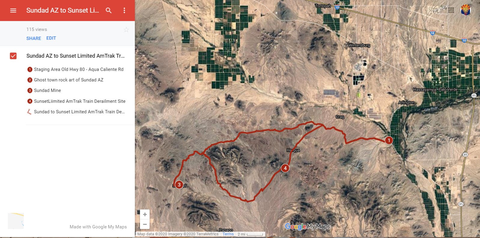
Sundad AZ to Sunset Limited AmTrak Train Derailment
© Phoenix ATV/UTV Club
Trail Rating: Easy-Moderate (Level 1-2; Green-Blue)
75.5 miles (717'-1486')
Southwest of Phoenix
near Arlington AZ
- Sundad Mine
- Ghost Town Rock Art of Sundad AZ
- Sunset Limited AmTrak Train Derailment Site
GPS Track + Map
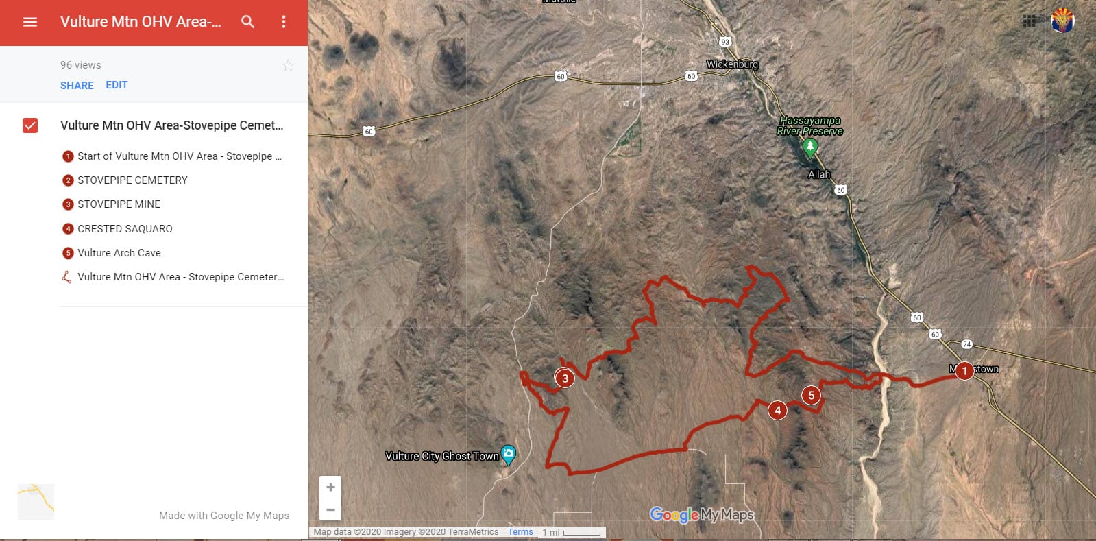
Vulture Mtn OHV Area
Stovepipe Cemetery & Mine + Vulture Arch Cave
© Phoenix ATV/UTV Club
Trail Rating: Moderate
(Level 2; Blue)
42.2 miles (1598'-2587')
Vulture Mtn OHV Area
+ Stovepipe Cemetery & Mine
+ Crested Saquaro
+ Vulture Arch Cave
GPS Track + Map
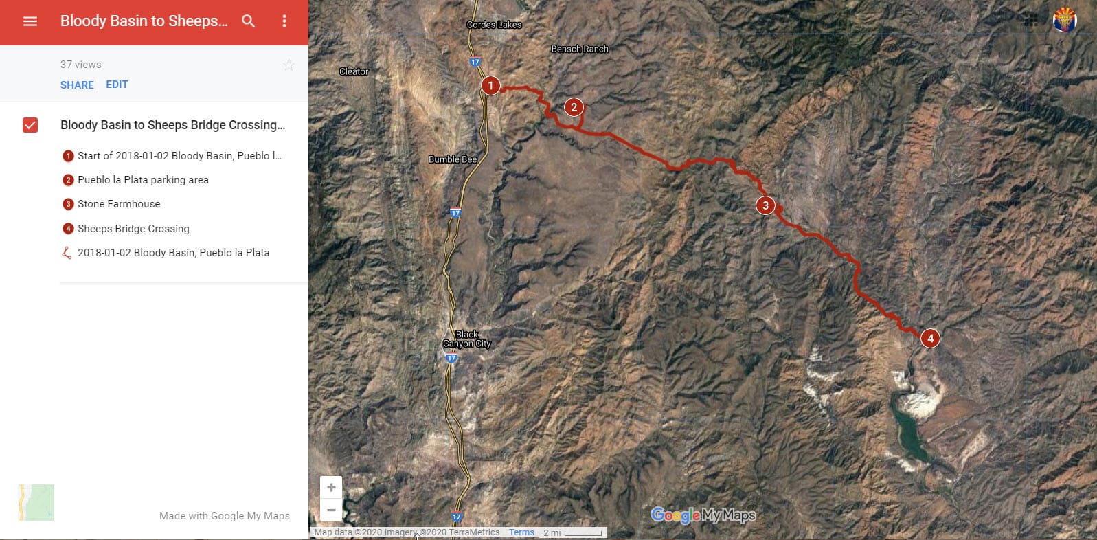
Bloody Basin to Sheeps Bridge Crossing
© Phoenix ATV/UTV Club
Trail Rating: Moderate
(Level 2; Blue)
79.9 miles (2250'-4930')
Bloody Basin Area
Pueblo La Plata Indian Ruins
+ historical Sheeps Bridge Crossing on the Verde River
GPS Track + Map
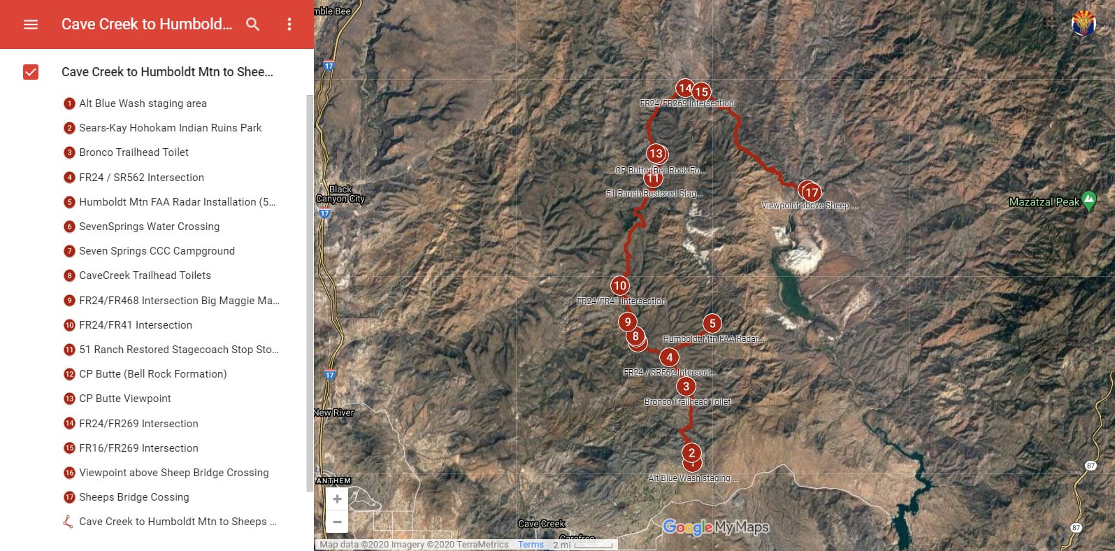
Cave Creek to Humboldt Mtn to Sheeps Bridge Crossing
© Phoenix ATV/UTV Club
Trail Rating: Easy - Moderate
(Level 1-2; Green-Blue)
87.5 miles (2065'-5136')
N Scottsdale/Carefree AZ
Cave Creek Mining District riding area
Cave Creek Road FR24 - Bronco Trailhead - Humboldt Mtn FAA Radar Installation - Seven Springs CCC Campground - Cave Creek Trailhead - 51Ranch Restored Stagecoach Stop Stone Cabin - CP Butte - Roundtree Canyon - Tangle Creek Campground - Sheeps Bridge Crossing on Verde River
GPS Track + Map
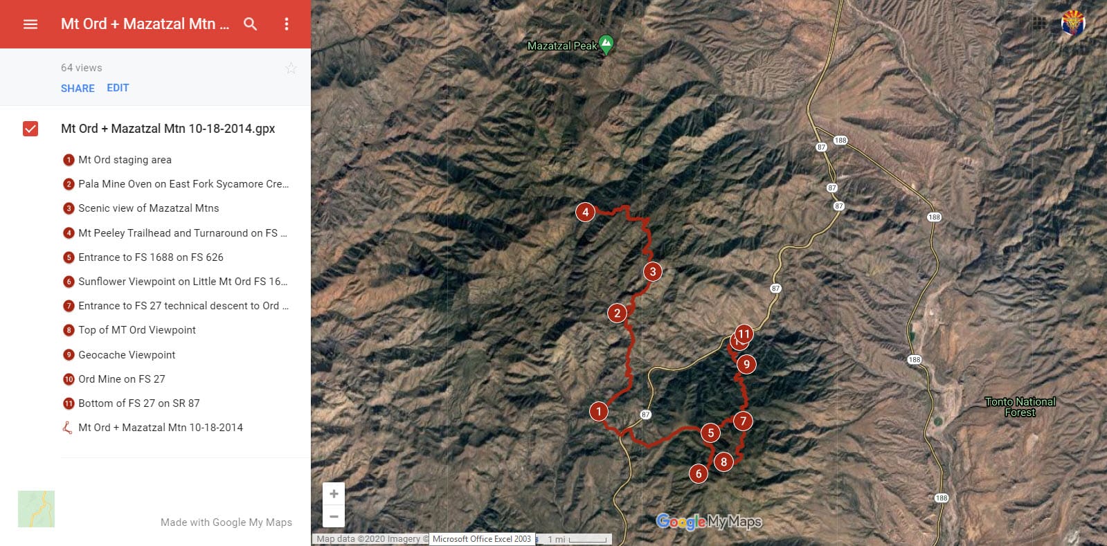
Mount Ord + Mazatzal Wilderness Area
© Phoenix ATV/UTV Club
Trail Rating: Easy - Moderate
(Level 1-2; Green-Blue)
47.5 miles (3605'-6729')
Mazatzal Wilderness Area
Mount Ord -Mt Peeley Trailhead - Mazatzal Wilderness Area - Pala Mine Oven - Little Mt Ord Viewpoint - Ord Mine - Mt Ord Viewpoint
GPS Track + Map
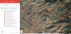
Four Peaks - EL Oso Mine Tour
© Phoenix ATV/UTV Club
Trail Rating: Easy-Moderate
(Level 1-2; Green-Blue)
45.0 miles (2600'-5800')
Four Peaks Wilderness Area
- Four Peaks/Lone Pines Summit via FR143
- EL Oso Mine Tour
- Mud Springs Trailhead
- Picadilla Creek Viewpoint
- Edward Peaks Trail on Mazatzal Divide
GPS Track + Map
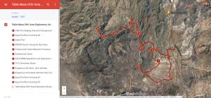
Table Mesa OHV Area
Exploratory Ride
© Phoenix ATV/UTV Club
Trail Rating: Easy-Moderate
(Level 1-2; Green-Blue)
30.3 miles (1726'-2631')
Table Mesa OHV Area
- Indian Fort
- 3 Aqua Fria River Crossings
- FR9959 Mtn Viewpoint
- Cottonwood Creek Crossing
- Cottonwood Wash Corral
- TV-3 "Terminator" Route
- Moore's Gulch I-17 Underpass
GPS Track + Map
Wickenburg-Stanton Goldfields/Ghost Town-Yarnell-St Joseph Shrine- Hassayampa River Box Canyon Ride
© Phoenix ATV/UTV Club
Trail Rating: Easy-Moderate
(Level 1-2; Green-Blue)
56.2 miles (2123'-4878')
Wickenburg OHV Area
- Two available staging areas:
- Wickenburg Rodeo Grounds Staging Area
- Sophie Flats Trailhead
Staging Area
- FR1370 Jeep Trail
- Stanton Goldfields
-Stanton Ghost Town
- Restaurants in Yarnell
- St Joseph Shrine of the Mountains
- Hassayampa River Box Canyon
- Hiking into Side Slot Canyon
GPS Track + Map
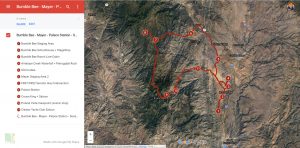
Bumble Bee - Mayer - Palace Station - Senator Hwy - Crown King - Cleator Loop Ride
© Phoenix ATV/UTV Club
Trail Rating: Easy-Moderate
(Level 1-2; Green-Blue)
87.6 miles (2514'-6544')
Bumble Bee OHV Area
- Bumble Bee Staging Area
- Bumble Bee Line Cabin
- Antelope Creek Waterfall & Pictograph Rock
- Old Cordes
- Mayer
- Palace Station
- Senator Hwy
- Crown King
- Poland Vista Viewpoint
- Cleator Yacht Club Saloon

GPS Track + Map
The Backway to Crown King Trail with a return route through Minnehaha Flats
© Phoenix ATV/UTV Club
Trail Rating: Moderate-Difficult
(Level 2-3; Blue-Red)
74.8 miles (1772'-6546')
Lake Pleasant OHV Area
Castle Hot Springs Resort
- Champie Road
- Backway to CK Trail
-Fort Misery
-Mendoza Memorial Site
-Oro Belle Mine
-Town of Crown King
-Senator Hwy
-Wagoner Road to Minnehaha Flats
GPS Track + Map
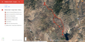
Walkers Gulch - Cooper Ranch - Walnut Grove Dam Disaster Site
© Phoenix ATV/UTV Club
Trail Rating: Easy-Moderate
(Level 1-2; Green-Blue)
71.7 miles (1732--4508')
Lake Pleasant OHV Area
- Castle Hot Springs Resort
- Walkers Gulch Trail
- 1880's Toll-road (French Creek Rd)
- 100+ yr old Cooper Ranch
- 1890 Walnut Grove Dam Disaster Site
- Return on Cow Creek Road
GPS Track + Map
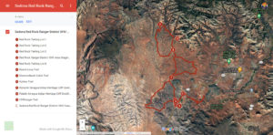
Red Rock Ranger District OHV Area
© Phoenix ATV/UTV Club
Trail Rating: Easy-Difficult
(Level 1-3; Green-Red)
45.1 miles (3804'-4790')
Red Rock Ranger District OHV Area
- Honanki Sinagua Indian Heritage Cliff Dwelling Site (1050-1350 AD)
-Palatki Sinagua Indian Heritage Cliff Dwelling Site (1050-1350 AD)
- Main N/S Arterial FR525 trail
(Easy: Level 1 - Green)
- Ranch Loop Trail
(Easy: Level 1 - Green)
-Diamondback Gulch Trail
(Difficult: Level 3 - Red)
-Outlaw Trail
(Moderate: Level 2 - Blue)
GPS Track + Map
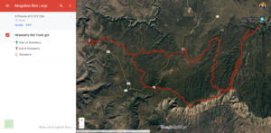
Mogollon Rim Loop Ride
© Phoenix ATV/UTV Club
Trail Rating: Easy-Moderate
(Level 1-2; Green-Blue)
74.8 miles (6232'-7841')
Mogollon Rim Area
Mogollon Rim FR300 Trail from town of Strawberry to Blue Ridge Reservoir
GPS Track + Map
Gila Box Canyon - Martinez Canyon
Loop Ride
© Phoenix ATV/UTV Club
Trail Rating: 40%Easy-60%Moderate
(Level 1-2; Green-Blue)
44.6 miles (1584'-2901')
Middle Gila Canyons
OHV Area
- Cottonwood Canyon Road Staging Area
- Mineral Mtn Mine Adit Tunnel
- Axel Alley Bypass around "The Waterfall"
- Martinez Canyon
- Optional Hike to Martinez Mine
- Smith Ranch Old Corral
- Gila Box Canyon
- Sandman Trail
- Weathervane Sign Post
GPS Track + Map
Sunset and Space Station NIGHT RIDE & Pizza Party
© Phoenix ATV/UTV Club
Trail Rating: Easy
(Level 1; Green)
22.5 miles (3200'-5150')
N Scottsdale/Carefree AZ
- Cave Creek Mining District riding area
- Meet-and-Greet pre-ride Pizza Party @ Sears-Kay Hohokam Indian Ruins (1050-1200AD)
- Bronco Trailhead
(vaulted toilet)
- Humboldt Mtn FAA Radar Installation & Viewpoint (5150' elev)
- Sunset and International Space Station Overhead Flyover
GPS Track + Map
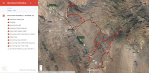
Morristown-Wickenburg Lunch Ride
© Phoenix ATV/UTV Club
Trail Rating: Easy-Moderate
(Level 1-2; Green-Blue)
67.5 miles (1785'-2858')
Jackass Flats OHV Area
- Gates Road Staging Area
- Jackass Flats Campground
- Tin Shed
- Anderson Mica Mill
- Old Stage Road
- Sophie's Flat Trailhead (vaulted toilets)
- Hassayampa River Box Canyon
- Slot Canyon in Box Canyon
- Lunch in Wickenburg
- Monarch Wash
- Dragon Mine
- China Dam (aka historic John Sanger Dam)
- San Domingo Wash Train Trestle
GPS Track + Map
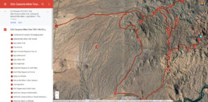
Gila Canyons Mine Tour
© Phoenix ATV/UTV Club
Trail Rating: Moderate-Difficult
(Level 2-3; Blue-Red)
54.7 miles (1624'-2969')
Middle Gila Canyons
OHV Area
- Cottonwood Canyon Rd Staging Area & Campground
Mineral Mtn Mine
- Five Points trails
-Ajax Crested Saquaro Cactus
- Ajax Mine & Ajax Mine Mill
- "The Waterfall"
- Waterfall Bypass via Axel Alley trail
- Marry Me Mine (Myers Mine?)
- Herring Mine
- Old Stagecoach Cabin Ruins
-Martinez Canyon trail
- Martinez Mine
-Old Smith Ranch Corral
- Gila Box Canyon (aka Florence Box Canyon)
Sandman Trail in Middle Gila Canyons OHV Area
- Oklahoma Mine
GPS Track + Map
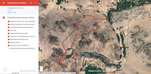
Painted Rock Petroglyphs Site & 1851 Oatman Massacre Site Ride
© Phoenix ATV/UTV Club
Trail Rating: Easy-Moderate
(Level 1-2; Green-Blue)
85.6 miles (507'-1283')
Southwest of Phoenix
near Arlington AZ
- Old Hwy US80/Aqua Caliente Road Staging Area
- Woolsey Peak Windmill & Buckeye Copper Mine
- Painted Rock Historical Petroglyphs Park (vaulted toilets)
- Oatman Stone Cabin
- Pioneer Fourr Family Stagecoach Stop & Cemetery
- Oatman Massacre Site
- Oatman Gravesite
- Sunset Ltd AmTrak Train Derailment Site