
- This event has passed.
PAUC Sedona Red Rock Ranger District OHV Area Ride
Saturday, Sept 26, 2020 Sedona Red Rock Ranger District OHV Area Ride
RIDE DESCRIPTION
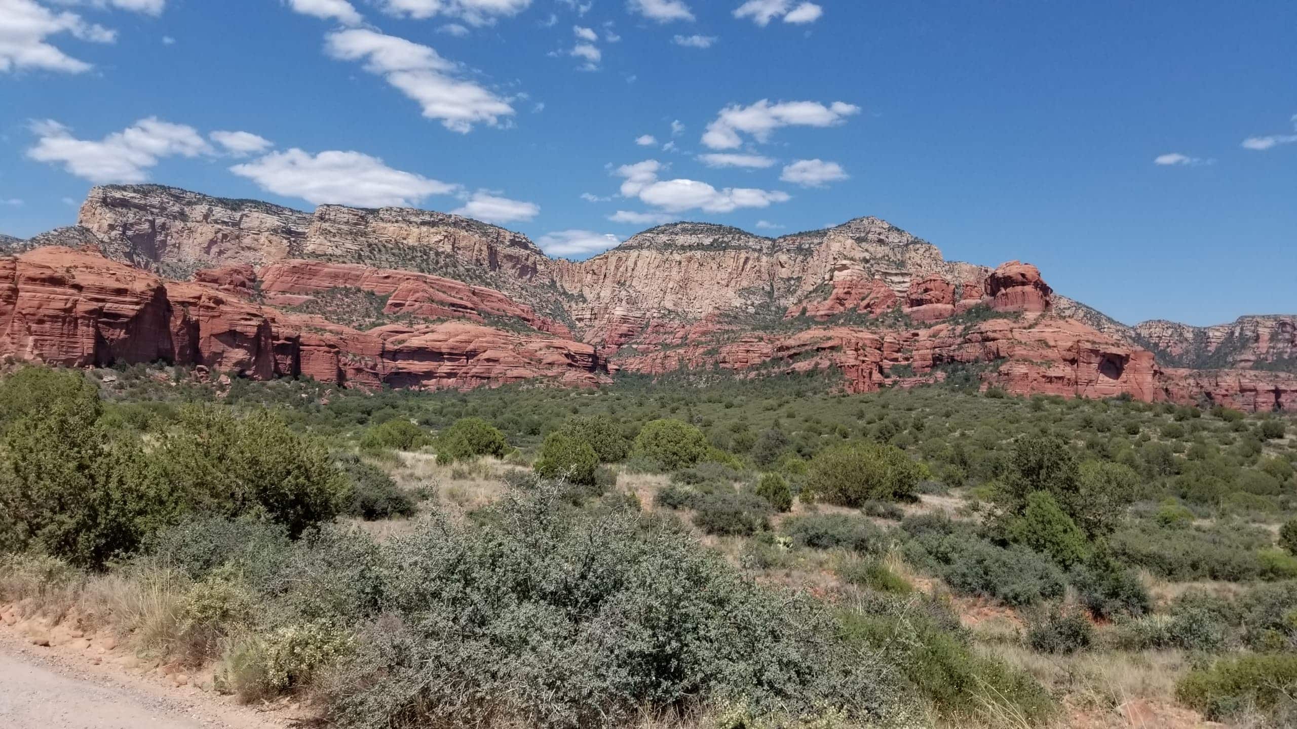
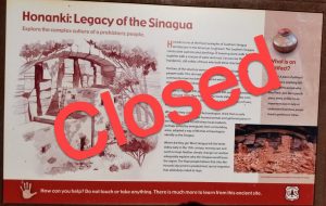
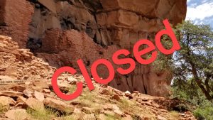
This is a summer and fall favorite to escape the heat. The Cottonwood/Sedona Red Rock Ranger District OHV Area is expecting sunny 61°–88° temps that Saturday. We have not done this ride for a while. Sadly, both the Honaki and Lapatki Indian Heritage cliff dwelling sites are CLOSED due to the Coconino Forest pandemic mitigation guidelines. There are limited dispersed camping spots within a ½ mile of the staging area at Parking Lot # 3 but it unknown about their availability in this high traffic season or if allowed due to the pandemic mitigation guidelines. Check with the Red Rock Ranger District or Coconino NFS websites for up-to-date advice. Our flight leaders are planning to drive on the main N/S arterial FR525 trail and adjoining Ranch Loop + Diamondback Gulch + Outlaw side trails in this scenic OHV Area. Check the TRAIL RATING section for trail section difficulty ratings.
There will be a 20-vehicle registration limit unless additional flight leaders volunteer to lead. This ride will only be open to PAID SUPPORTING MEMBERS (ie. no guest vehicles… have your friends join the club) and not opened to our Facebook group members. IF YOU HAVE AN EXTRA SEAT IN YOUR SXS OR UTV FOR THE RIDE, EMAIL ME OR FACEBOOK MESSAGE ME TO LET ME KNOW. There are always member guests and friends looking for an open seat offer to go on this fun scenic ride.
SOCIAL DISTANCING BETWEEN MEMBERS AND VEHICLES: Please observe public health directives of 6’-8’ between people and gatherings of <10 people. If necessary, we will go out on multiple flights to adhere to the public health guidelines. No handshaking or high-fives or hugging. Try to exercise caution and stay apart and off to the side of individuals instead of being downwind of them when talking. All vehicles will maintain adequate spacing to limit dust conditions and social distancing. If you don’t feel well or have not practiced self-quarantine for the past two weeks, DO NOT come on this ride and put others at risk! All participants MUST wear a mask or dust mask, kerchief, bandana, scarf, or other means of protective personal equipment for their personal safety as well as for the safety of other participants.
The Red Rock Ranger District OHV Routes Map is a FREE Avenza Map available for downloading onto your iOS or Android device using the FREE Avenza Maps app in Google Play. You must load the app and create an Avenza Maps account first to download it.
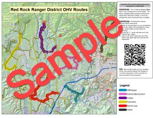
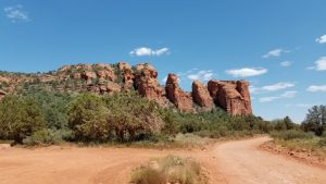
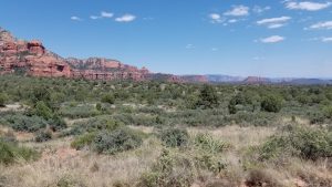
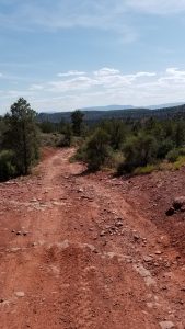


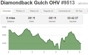
Photo and Elevation Graphic of Diamondback Gulch 9513 trail – courtesy of © Trailforks.com website
TRAIL RATING
This ride is rated an overall Easy-to-Moderate-to-Difficult Ride [Level 1–2–3, Green–Blue–Red]. Definition: Will have some spots that are off-cambered; hilly/rocky spots and some steep slopes; recommended for riders with more than 12 months of riding experience). UTVs / SxSs / ROVs okay on this trail. Not recommended for 2WD vehicles, sports quads, or Two-Up ATVs for passengers. Low range gear recommended for the Diamondback Gulch trail and parts of the Outlaw trail. Attendees not wishing to take the scenic Difficult Level 6-mile Diamondback Gulch trail can leave the group and bypass that section on the Easy FR525.
- Main arterial N/S FR525 trail (Easy Level 1, Green]
- Ranch Loop trail (Easy-to-Moderate Level 1–2, Green–Blue]
- Diamondback Gulch trail (Difficult Level 3, Red] = “Pink Jeep Tour route”
- Outlaw trail (Easy-to-Moderate Level 1–2, Green–Blue]
- Cliffhanger trail (Easy-to-Moderate Ride [Level 1–2, Green–Blue] if time permits.
REFERENCE SCALE FOR DIFFERENT TRAIL BOOK RATINGS
Easy / Moderate / Difficult / Extreme = Green / Blue / Red / Black = Levels 1 / 2 / 3 / 4.
STAGING AREA AND START TIME
The staging area is about 105 miles (min. 2 hr drive) north of Phoenix between Cottonwood and Sedona. We don’t recommend driving through Sedona via AZ-179 to 89A due to Sedona traffic. Allow for traffic delays to arrive an hour early to find parking and unload your vehicle and drive to sign-in at the staging registration table.
Drive north on I-17 up to the Camp Verde/Cottonwood exit 287. Turn NW on AZ-260 and head 14 miles to Cottonwood AZ to AZ-89A. Turn NE onto AZ-89A and go 8 miles towards Sedona to FR525 Loy Butte Road and turn left (north) on FR525. There are 3 parking lots on FR525 and #4 is on the southeast side of AZ-89A on Angel Valley Road. The staging area is 1200’ N of Hwy 89A on FR525 Loy Butte Road. You can view it on the Google Maps Satellite view at coordinates 34°49’08.2″N 111°54’19.8″W or (Google coordinates 34.818934, -111.905504) OR download our Google Map Feature at the bottom of the ride description to get turn-by-turn cellphone instructions from your home on your way.
The SAFETY MEETING will be at 8:45AM. The flights will depart at 9:00AM and return approximately 5:00PM. Arrive an hour early to find parking and unload your vehicle and drive to sign-in at the staging registration table.
STAGING AREA LOT (no recovery vehicle parking except for ride leaders & registration volunteers)
= 1200’ N of Hwy 89A on FR525 Loy Butte Road [ 34°49’08.2″N 111°54’19.8″W (34.818934, -111.905504) ]
Parking area #1 (8-10 vehicles & trailers) = 200’ N of Hwy 89A on FR525 Loy Butte Road
[ 34°48’54.7″N 111°54’19.6″W (34.815204, -111.905450) ]
Parking area #2 (3 vehicles & trailers) = 800’ N of Hwy 89A on FR525 Loy Butte Road
[ 34°49’02.2″N 111°54’16.9″W (34.817276, -111.904695) ]
Parking area #3 (20 vehicles & trailers) = 2400’ N of Hwy 89A on FR525 Loy Butte Road (600’ past FR761B)
[ 34°49’08.2″N 111°54’19.8″W (34.818934, -111.905504) ]
Parking area # 4 (6-7 vehicles & trailers) = 900’ South of Hwy 89A on Angel Valley Road
[ 34°48’49.5″N 111°54’03.0″W (34.813735, -111.900844) ]
FLIGHT LEADERS AND TAILGUNNERS NEEDED
Bill Poppo and I are looking for an experienced member with a radio to volunteer as our tailgunners. Otherwise, a responsible rider will be appointed at the staging area. Other riders with radios can volunteer as mid-pack wingmen to maintain radio contact. We are also looking for another flight leader.
ROTATION METHOD
We will use the “rotation method” on this ride because of the many turns and forks in this popular OHV Area. We still collapse the flight groups occasionally at major turns to maintain radio contact and insure that people followed the correct route. Bob and Bill use a “rotation method” on some club rides where the ride leader stops at the turn to drop off the #2 vehicle (pin) before proceeding with vehicle #3. The dropped pin #2 vehicle directs all the following riders onto the correct trail and then rejoins the group at the back of the pack in front of the tailgunner vehicle. This “rotation method” limits a slow vehicle from losing sight of the group and taking everyone behind them down a wrong trail trying to catch up or inadvertently following another group. It also allows the ride leader to maintain a good pace and assess trail conditions ahead and to check his GPS track. We will also attach colored trail marker tape to every vehicle’s bumper or roll cage so we can identify our different flight groups from other vehicles riding in this popular OHV area. There have been times where riders started following some other group or dust trail by mistake and taking everyone behind them down the wrong trail. Not everyone brings radios to hear the turn instructions and approaching traffic announcements.
POST-RIDE DESERT DESSERT BAR
It has not been decided if we will be hosting a post-ride Desert Dessert Bar (sodas, water, cookies, cake slices, brownie bites) at this time due to the multiple parking lots and people anxious to drive home at the end of the ride.
COMMUNICATION
Leader, mid-pack wingmen, and tailgunner will be on GMRS/FRS Channel 5 (sub-channel 0) in case you want to bring your walkie-talkies or CB / HAM radios. The corresponding UHF channel frequency is 462.6625 MHz depending on your radio. I highly recommend bringing a walkie-talkie to listen to approaching traffic and trail conditions.
VEHICLE & EQUIPMENT REQUIREMENTS
All ATVs, UTVs, & SxSs should be street-legal and have the Arizona Off Highway Vehicle Decal sticker. Dress appropriately and keep hydrated. BRING A TRAIL LUNCH, SNACKS, AND BEVERAGES. Bring a camera for those Kodak moments. TOTAL MILEAGE WITH SIDE TRIPS IS APPROXIMATELY 40 MILES in the OHV Area. Extra fuel is usually not required but each rider should know their machine’s fuel consumption. Gasoline is available in Cottonwood. We should arrive back at the staging area around 5:00PM.
Helmet that is properly fitted, fastened, and has a USDOT safety rating for those 18 years of age and younger who ride on an OHV. Riders in an OHV such as a ROV / UTV / SxS or similar vehicle, while recommended for safety, do not require a helmet unless a rider is under 18 years of age. The Phoenix ATV/UTV Club promotes the use of helmets on all its rides. Eye protection is required for operators of vehicles not equipped with a windshield. You should use common sense for eye protection, bandanas, scarves, and dust masks for large group riding due to the dust conditions anyway.
SAFE, ETHICAL and RESPONSIBLE OPERATION OF YOUR VEHICLE
All Phoenix ATV/UTV Club members, visitors, and guests are expected to have appropriate vehicle registration, license, and personal insurance and to operate their vehicles in a responsible manner. The Phoenix ATV/UTV Club is a responsible member of the OHV riding community. As such the Club promotes safe and responsible operation of OHVs during club rides. Arizona Revised Statute 28-1381 prohibits the operation of motorized vehicles, including OHVs, while under the influence of any substance that may impair the operator’s judgment or ability. Therefore, the Club prohibits the consumption or use of any substance during a club ride that has the potential to impair the operator’s judgment or ability.
“Come join us for a fun ride and explore some local historical stops and trails and make new friends!”
Live to Ride… Ride to Live! Happy Trails…
Bob Maitzen
Phoenix ATV/UTV Club
(480) 363-7723
Bob.Maitzen@gmail.com
Hi All – This is my 1st ride with the group. Any advice other than just read directions and show up at the staging coords early?
Hi Foster,
We were just informed that ADOT is closing down the northbound lane of I-17 between Deer Valley and Jomax Road starting on Saturday morning at 2AM for repaving. Please allow yourself extra travel time to take a detour around that closure. I assume you are in the Valley and not driving in from Sioux Falls. Ha-ha! How long have you been riding? Bring a trail lunch, snacks, and beverages for the ride and it is always good to arrive early to unload and sign in at the registration table and line up for a flight. Since you are a new member, we want to make that new members are aware of the Already Registered feature on a ride posting. If for some reason, you can’t make the ride (mechanical, health, flat tire, etc), click the Already Registered link to “unregister” for a ride so the ride leaders know you aren’t coming..
See you on Saturday. Let me know if someone is coming with you so I can make a name tag for them.