Ride Summary – Dec 22, 2018 Table Mesa-Indian Fort-Tip Top Mine ride
Bill P’s grown sons, Anthony & Mike, came out to visit their Dad for the Christmas Holidays and to do a couple of days of ATV riding. I was fortunate to join them on a private ride on Saturday in the Table Mesa Recreation Area. We had excellent sunny cool riding weather for a nice afternoon ride out to the Indian Fort and Tip Top Mine.. The Tip Top Mine ride is one of Bill’s favorites and one of my Four Points of the Compass rides. I also call it a Play-It-Forward ride so people can show others the route in the future.
We were suppose to meet out at the Little Pan Staging Area at 9:30AM but they had an hour delay loading up their 3 quads into the truck bed and trailer and all the BBQ food, firewood, gear, helmets, and installing new helmet radios for the occasion. Bill and his sons were planning to do a post-ride BBQ and campfire after the ride so their truck’s backseat was packed to the max! Ha-ha!
Meanwhile, I kept myself busy assisting 1/2 dozen vehicles (Jeeps & UTVs) at the kiosk answering questions about the riding area and pointing out on the kiosk map how to get to the Indian Fort, Tip Top Mine, and Terminator trail. One couple had a FunTreks trailbook which was helpful but they were still a little confused with all the trails in that popular OHV area. I forgot to bring my extra copies of the BLM trail maps so I recommended taking a smartphone photo of the kiosk map to use on the trail. I also handed out a dozen Phoenix ATV/UTV Club business cards out to people that day.
TRAIL REFERENCE BOOKS
The route is noted on pages 81-83 of the FUNTREKS ATV TRAILS GUIDE-ARIZONA (Phoenix Region) by Charles A. Wells & Matt Peterson. The route is noted on pages 98-99 of the FUNTREKS GUIDE TO ARIZONA BACKROADS & 4-WHEEL-DRIVE TRAILS by Charles A. Wells & Matt Peterson.
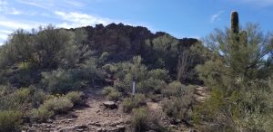
INDIAN FORT
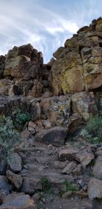
The general riding area is northwest out of the Table Mesa OHV Recreation Area. Set OHV odometer to zero (0) at the Little Pan staging area and campground (vaulted toilets) [N34° 00.233’ W112° 09.690’]. After unloading the quads and getting the new helmet radios working, we departed at 11:30AM with Bill as the ride leader and Bob as the tailgunner. We headed west on the 9998 trail and down to the Aqua Fria River Crossing #2 [N34° 00.890’ W112° 09.690’] which is usually a shallow stream at this time of year (15′ wide and 1′ deep). There is usually year-round water at that crossing due to watershed runoff and some nearby springs. We turned north on 9999 and went for a few miles to the 9984/9985 loop trail to the Indian Fort [N34° 00.967’ W112° 10.961’] for our first scenic stop at 3.0 miles from the staging area. All of us had been there before so we did not climb the 20′ narrow slot crevasse to the top of the defensible Indian Fort mesa (great photo stop). I highly recommend climbing up the slot crevasse for a great view of the Agua Fria river (indian trade route) and surrounding landscape. After a water bottle break, we departed making a counterclockwise exit on the 9984/9985 loop trail (moderate-level-rated loose rock) back to 9999 where we headed north to the 9959 trail by the corral. We ascended on the uphill section with a photo rest stop at the top viewpoint [N34° 01.837’ W112° 12.770’] before our descent down to Cottonwood Creek wash.
TRAIL REPAIR & REVISED TRAIL RATING
I want to give a big THANK YOU shoutout to the BLM, Arizona State Parks, OHV Ambassadors, National Forest Service, and Arizona OHV Decal Funds/Grant money for their efforts on grading the 9959 trail last year all the way out to the Tip Top Mining District. They did a great job in grading the Difficult-to-Black Diamond trail sections. This year’s hard rains have made some new V-crevasses on parts of the 9959 trail. Most of the off-cambered powdery moguls and V-crevasses on the uphill climb were knock down somewhat. The downhill section to Cottonwood Creek has a Moderate trail rating with only a few bedrock sections and some loose rock at the bottom as a reminder of past travels and trail stories. There is one bedrock section at the junction of Boulder Creek/Cottonwood Creek that still requires some careful negotiation.
TRAIL RATING
Overall, after last year’s trail repair, I have to downgrade this ride’s trail rating from Moderate-to-Difficult (Level 2-3; Blue-Red) and the occasional Black Diamond (Level 4; Black) trail rating down to an overall Moderate (Level 1-2; Green-Blue) rating now. I encourage our club members to visit the Tip Top Mine while the riding weather and trail conditions are so favorable. Again, kudos to the state and federal agencies and volunteer organizations for this historical trail repair.
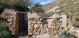
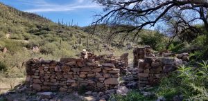
TIP TOP MINE
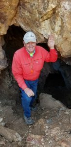
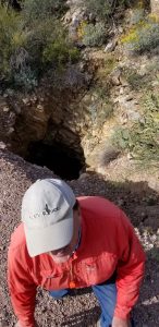
At the stone cabin remains of the Tip Top Mine Saloon/Assay Office [N34° 03.061’ W112° 14.836’], Bob gave a short Tip Top Mine history lesson while we enjoyed lunch and shared trail stories. Odometer reading = 10.9 miles from staging area. We don’t go up to the northeast main Inclined Shaft Tip Top Mine Opening as you approach the “town” anymore. That trail has eroded too much with loose rock resulting in a few ATV rollovers and injuries. The Tip Top Mine penetrated the whole mountainside and went down over 800′ with many offshoot tunnels at each 100′ following the rich silver & tungsten ore veins.
FASCINATING HISTORY, MAPS, AND OLD PHOTOS OF TIP TOP MINE AREA
There is an interesting online website provided by Neal Du Shane of the Arizona Pioneer & Cemetery Research Project (APCRP). Neal is a great historian and speaker on many Arizona mines history and notable pioneer families. We encourage you to look at his APCRP website and to DONATE to its cause.
http://www.apcrp.org/Tip%20Top/TipTop%20Master%20Text%20II.htm
KEYSTONE/JOKER MINE?
The north side mining trail up to the old Tip Top horizontal adit tunnel (across from the assay office/saloon stone ruins) has eroded and is impassable and would be a challenge for even hikers now. After lunch, we explored the Keystone/Joker Mine? [N34° 03.094’ W112° 14.951’] by driving up a mining trail down the road on the south side. There are 3 adit tunnels and pit shaft openings in the hillside. I’ll try to attach some photos of that mine. I called it the Keystone/Joker Mine because of its location on one of 14 mining claims there. Each mining claim was 600’x1500′ so the entire valley was worked by different adjoining claims. There is only enough room for 4 quads or 2 UTVs at the mine openings so take turns going up there if traveling with a large group. The trail is only 60″ wide. We waved to 1/2 dozen UTVs as they drove by but they never looked up to see us.
SEVENTY-SIXER MINE
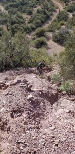
Next, we went down to the Seventy-Sixer Mine [N34° 03.169’ W112° 15.351’] just outside the Tip Top mining community. The valley has plenty of visible stone retaining walls and old cabin foundations along the creek bed if you look for them. At the height of its glory, the Tip Top area had a population of 200+ with 6 saloons, three stores, four restaurants, laundries, and other enterprises. Bob always wanted to explore the Seventy-Sixer Mine but he was always leading a group ride. Our small party stopped for Bob to explore and fulfill his curiosity. Needless to say, it was a challenging 60-degree 200’+ uphill hike (handcrawl) using a v-crevasse in the loose mine tailings to view the 25′-wide mine’s deep pit shaft at the top. We had to butt-slide down the mine tailings allowing each person to descend safely before the next person due to the loose rocks causing small rock slides. As the saying goes…”Curiosity can kill the cat” which is a proverb used to warn of the dangers of unnecessary investigation or experimentation. I would state that seeing the mine opening is not worth the effort and danger to get to it but at least Bob has ticked off another historical mine on his exploratory travels list.
BOULDER CREEK RANCH STABLES
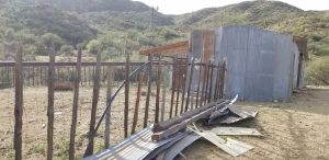
We continued our way out to the Boulder Creek Ranch stables [N34° 03.333’ W112° 16.488’] where we turned around from our day’s adventure. Odometer reading = 16.9 miles from the staging area. The stables, windmill, and horse barns are at the junction of many trails.
FYI — The southbound trail behind the stable barn and windmill goes over the mountain range coming out at the Columbia Trail intersection with Cow Creek Road (north of Lake Pleasant). It had a Difficult-to-Black Diamond trail rating (10 years ago). The westbound Moderate-rated trail goes out to the historical Little Joe Mine and Acquisition Mine (which is on posted property ground as of 2018). The owners have been removing all of the old conveyor belts, mining equipment, and settlement tanks from that historical mine over the past year. The northbound trail out of the stables heads out to the historical MLK Ranch.
We returned on the same route with one rest stop at the Cottonwood Creek waterhole [N34° 01.662’ W112° 13.625’] before ascending the 9959 trail. We arrived back at the Little Pan Staging Area at 4:00PM. The length of the ride with our exploratory side trips was 25.5 miles in length and 4.5 hours (avg speed 15MPH). Overall, it was a nice fun ride with great scenic views and a great group of riding buddies. Contact me if you have questions about the riding area. Live to Ride… Ride to Live!
Happy Trails to You… Until We Meet Again…
Bob Maitzen