Ride Summary – April 7th Cave Creek – Humboldt Mtn – Big Maggie May Trail ride
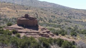
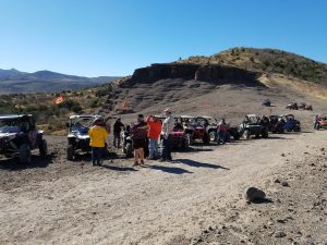
Article by Bill Poppo – It was a nice day for another Phoenix ATV/UTV Club ride. Our vehicle recovery parking area was at Mile Marker 2.2 on the Cave Creek/Seven Spring Road at the Camp Creek Trailhead with a short 0.5 mile ride to the morning staging area at the Sears-Kay Hohokam Indian Ruins with its gazebos and vaulted toilets. There were 15 vehicles: 1 ATV and 14 SxSs (take a guess on who piloted the lone ATV), with a total of 25 people. No one walked up to the hillside Sears-Kay Hohokam Indian Ruins but instead enjoyed the meet-and-greet Donuts & OJ breakfast in its gazebo parking area as we waited for everyone.
The ride has a Easy-to-Moderate (Level 1-2; Green-Blue) trail rating.
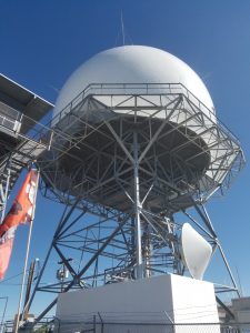
It was a pretty uneventful and easy ride. We were a little late on the safety meeting and left the staging area about 30 minutes later than planned (about 9:30 AM). Most of the ride is on the graded two-lane dirt Cave Creek/Seven Springs Road (FR24). Our first stop after leaving the Sears-Kay staging area was the Bronco Trailhead vaulted toilets for a brief bathroom break. Afterwards. we headed north on FR24 to the SR562 road heading east 4 miles up to the FAA Radar Installation at 5150′ on the top of Humboldt Mountain. I think everyone was impressed with the views from that spot overlooking Horseshoe Lake and the surrounding Cave Creek Mining District mountains, as it was a fairly clear day.
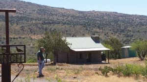
We returned back to FR24 off Humboldt Mountain heading north again with the next stop being the Cave Creek Trailhead vaulted toilets near the Seven Springs CCC Campground for another bathroom break. After everyone mingled and used the facilities, we took a trip down Grey Gulch Switchbacks on the Big Maggie May Trail (FR468) where we had lunch by the Big Maggie May Stone Cabin ruins. We arrived at about 11:30 and spent about an hour enjoying lunch there. It seemed a bit early to turn back to the staging area so we returned to FR24 and ventured north to the “51Ranch” ranch so everyone could see their restored stagecoach stop stone cabin at the ranch entrance. We then continued further north on FR24 to CP Butte (Bell Rock Formation) for a photo meet-and-greet break. I didn’t think we had enough time to make it to Bob’s Secret Spot up by Bloody Basin Road and be back before nightfall so we spent about 45 minutes or so at CP Butte. Some of the more courageous SxS riders climbed the nearby steep hill. We had got there around 1:30 and left about an hour later for our southbound return towards the staging area.
It was a fast ride back towards the staging area with a few brief stops to collapse the group. One of those stops was at the FR24/FR41 intersection (east entrance of FR41 New River Canyon Trail) for a welfare check and to maintain radio contact. The group started back with the next stop being the Cave Creek Trailhead for a real break. After a few minutes, we were notified by radio someone in the back of the pack had a flat. Mike and Joan Koep took most of the group to the trailhead as I turned back.
Turns out Don Fowler had a flat tire. However, Ray Hidalgo had a hydraulic jack, Albert Leslie had an impact wrench and Don had a spare tire. By the time I got back to the intersection, which couldn’t have been more than a mile and a half, 5 minutes max, the new tire was on. The team changed that tire so fast, I would classify them as the caliber of NASCAR! From there it was off to the trailhead to rejoin the group!.
We stopped for a while at the trailhead in case anyone needed to use the facilities, naturally exchanged pleasantries, then continued southbound to the Bronco Trailhead for one last break to use the facilities. By that time, some members had had enough and left directly back to the staging area, bypassing Bronco.
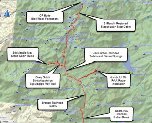
We arrived back the staging area about 4 PM…. Total miles was around 64 or so. Hard to tell since my odometer hasn’t been accurate since I put new tires on and I didn’t record the ride on my GPS. Bob Maitzen provided the Map Graphic from one of our previous rides. The pictures are those that some riders had posted on our club’s Facebook page. Check out the club’s Facebook website to see all the ride photos.
Live to Ride… Ride to Live! Bill Poppo